Query, subset, and/or summarize HarvestChoice indicators
Workhorse method to query, subset and/or aggregate HarvestChoice layers. This
method may also be used to summarize classified variables along intervals of
continuous variables, e.g. getLayer(var="AEZ16_CLAS", by="bmi"). The
dominant class of a variable var is defined as dominant(var).
Variables may also be summarized over custom geographic areas (passed as an integer
array of gridcell IDs). Note that calling getLayer is equivalent to
using the convenience method hcapi with the same arguments.
getLayer(var, iso3 = "SSA", by = NULL, ids = NULL, collapse = TRUE,
  as.list = FALSE)
Arguments
- var
- character array of variable names (all types are accepted). Use e.g.
category("poverty")to search for valid variable codes). - iso3
- optional array of 3-letter country or regional code(s) to filter by.
Use
isoto view all available codes. - by
- optional character array of variables to summarize by (all types are accepted)
- ids
- optional array of gridcell ids to filter by (if
collapse=FALSE) or summarize by (if collapse=TRUE). - collapse
- if TRUE results are collapsed (summarized) over
byvariables. If FALSE always return all pixel values (useful for plotting and to convert the resulting table to spatial formats) - as.list
- if TRUE returns a list with variable metadata instead of a simple data.table
Value
a data.table or list of var indicators aggregated by by
domains
Details
Sample API call: mean body mass index and maize yield across districts in Tanzania
$ curl http://hcapi.harvestchoice.org/ocpu/library/hcapi3/R/hcapi/json
 -d '{"var" : ["AEZ8_CLAS","bana_h"], "iso3" : "CIV", "by" : ["ADM1_NAME_ALT","ELEVATION"]}'
 -X POST -H 'Content-Type:application/json'
See also
hcapi and getLayerWKT
Examples
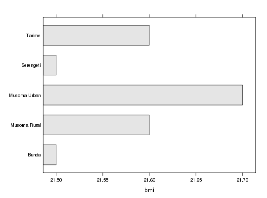
# Mean body mass index and maize yield across districts in Tanzania x <- getLayer(c("bmi", "maiz_y"), iso3="TZA", by=c("ADM1_NAME_ALT", "ADM2_NAME_ALT")) x#> ISO3 ADM0_NAME ADM1_NAME_ALT ADM2_NAME_ALT bmi #> 1: TZA United Republic of Tanzania Arusha Arumeru 21.2 #> 2: TZA United Republic of Tanzania Arusha Arusha 22.2 #> 3: TZA United Republic of Tanzania Arusha Karatu 21.2 #> 4: TZA United Republic of Tanzania Arusha Monduli 21.2 #> 5: TZA United Republic of Tanzania Arusha Ngorongoro 21.2 #> --- #> 124: TZA United Republic of Tanzania Unguja North North B 21.7 #> 125: TZA United Republic of Tanzania Unguja South Central 22.9 #> 126: TZA United Republic of Tanzania Unguja South South 23.2 #> 127: TZA United Republic of Tanzania Unguja Urban West West 23.2 #> 128: TZA United Republic of Tanzania buffer gridcell buffer gridcell NaN #> maiz_y #> 1: 2767 #> 2: NaN #> 3: 2074 #> 4: 1816 #> 5: 1159 #> --- #> 124: NaN #> 125: NaN #> 126: NaN #> 127: NaN #> 128: NaN# Plot results for Mara province require(lattice)#>barchart(ADM2_NAME_ALT~bmi, x[ADM1_NAME_ALT=="Mara"], col="grey90")# The method may be expanded to summarize classified (discrete) variables along # intervals of continuous variables. For example the call below returns the dominant # agro-ecological zone and total banana harvested area over Ivory Coast's provinces # and elevation zones x <- hcapi(c("AEZ8_CLAS", "bana_h"), iso3="CIV", by=c("ADM1_NAME_ALT", "ELEVATION")) x#> ISO3 ADM0_NAME ADM1_NAME_ALT ELEVATION AEZ8_CLAS bana_h #> 1: CIV Ivory Coast 18 Montagnes NA Humid 66 #> 2: CIV Ivory Coast 18 Montagnes (3e+02,5e+02] Humid 456 #> 3: CIV Ivory Coast 18 Montagnes (5e+02,9e+02] Sub-Humid 86 #> 4: CIV Ivory Coast 18 Montagnes (9e+02,1e+03] Humid 23 #> 5: CIV Ivory Coast Agneby NA Humid 322 #> 6: CIV Ivory Coast Bafing NA Sub-Humid 0 #> 7: CIV Ivory Coast Bafing (3e+02,5e+02] Sub-Humid 86 #> 8: CIV Ivory Coast Bafing (5e+02,9e+02] Sub-Humid 15 #> 9: CIV Ivory Coast Bas Sassandra NA Humid 874 #> 10: CIV Ivory Coast Bas Sassandra (3e+02,5e+02] Humid 78 #> 11: CIV Ivory Coast Denguele (3e+02,5e+02] Sub-Humid 78 #> 12: CIV Ivory Coast Denguele (5e+02,9e+02] Sub-Humid 4 #> 13: CIV Ivory Coast Fromager NA Humid 287 #> 14: CIV Ivory Coast Fromager (3e+02,5e+02] Humid 8 #> 15: CIV Ivory Coast Haut-sassandra NA Humid 304 #> 16: CIV Ivory Coast Haut-sassandra (3e+02,5e+02] Humid 404 #> 17: CIV Ivory Coast Lacs NA Sub-Humid 236 #> 18: CIV Ivory Coast Lagunes NA Sub-Humid 460 #> 19: CIV Ivory Coast Marahoue NA Humid 318 #> 20: CIV Ivory Coast Marahoue (3e+02,5e+02] Humid 58 #> 21: CIV Ivory Coast Moyen Comoe NA Humid 231 #> 22: CIV Ivory Coast Moyen Comoe (3e+02,5e+02] Humid 6 #> 23: CIV Ivory Coast Moyen-Cavally NA Humid 177 #> 24: CIV Ivory Coast Moyen-Cavally (3e+02,5e+02] Humid 247 #> 25: CIV Ivory Coast N'zi Comoe NA Sub-Humid 428 #> 26: CIV Ivory Coast N'zi Comoe (3e+02,5e+02] Sub-Humid 6 #> 27: CIV Ivory Coast Savanes NA Sub-Humid 3 #> 28: CIV Ivory Coast Savanes (3e+02,5e+02] Sub-Humid 158 #> 29: CIV Ivory Coast Savanes (5e+02,9e+02] Sub-Humid 0 #> 30: CIV Ivory Coast Sud Bandama NA Sub-Humid 457 #> 31: CIV Ivory Coast Sud Bandama (3e+02,5e+02] Humid 13 #> 32: CIV Ivory Coast Sud Comoe NA Humid 299 #> 33: CIV Ivory Coast Vallee Du Bandama NA Sub-Humid 238 #> 34: CIV Ivory Coast Vallee Du Bandama (3e+02,5e+02] Sub-Humid 140 #> 35: CIV Ivory Coast Worodougou NA Sub-Humid 28 #> 36: CIV Ivory Coast Worodougou (3e+02,5e+02] Sub-Humid 258 #> 37: CIV Ivory Coast Worodougou (5e+02,9e+02] Sub-Humid 2 #> 38: CIV Ivory Coast Zanzan NA Sub-Humid 224 #> 39: CIV Ivory Coast Zanzan (3e+02,5e+02] Sub-Humid 200 #> 40: CIV Ivory Coast Zanzan (5e+02,9e+02] Sub-Humid 9 #> 41: CIV Ivory Coast buffer gridcell NA NA 0 #> ISO3 ADM0_NAME ADM1_NAME_ALT ELEVATION AEZ8_CLAS bana_h